File:Hailstorm.jpg

本预览个尺寸:800×516像素。 其他分辨率:320×206像素 | 640×413像素 | 1,024×661像素 | 1,280×826像素 | 1,848×1,192像素。
原始文件 (1,848×1,192像素,文件大小:2.28 MB,MIME类型:image/jpeg)
小结
| 相机位置 | | 在以下服务上查看本图像和附近其他图像: OpenStreetMap |
|---|
| 描述 |
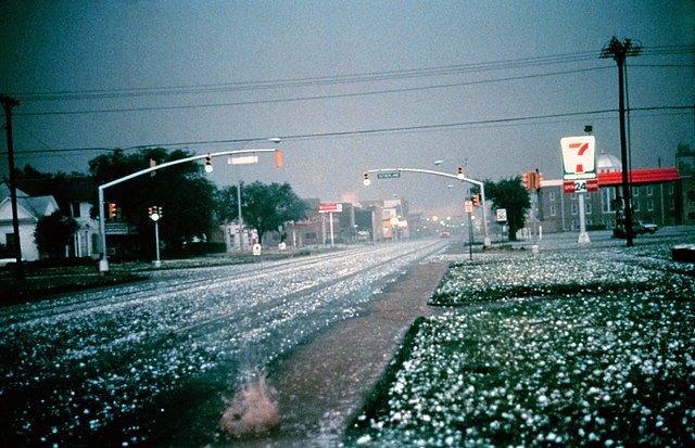
English: Large hail collects on the street and grass during severe thunderstorm. Larger stones appear to be nearly 2 to 3 inches in diameter. Photo taken in Altus, Oklahoma by the NOAA National Severe Storms Laboratory's storm intercept team in the hail core of a supercell thunderstorm that later produced an F2 tornado.
Français : Grosse grêlons de 5 à 8 cm de diamètre lors d'un orage violent. |
| 日脚 | |
| 来源 | http://www.photolib.noaa.gov/htmls/nssl0003.htm, http://ewp.nssl.noaa.gov/projects/shave/ |
| 作者 | NOAA Photo Library, NOAA Central Library; OAR/ERL/National Severe Storms Laboratory (NSSL) |
授权协议
本图像属于公有领域,因该作品最初来自于美国国家海洋和大气管理局职员的职务作品。
|
文件历史
揿一个日脚/辰光来望当时出现过个文件。
| 日脚 / 辰光 | 微缩图 | 维度 | 用户 | 备注 | |
|---|---|---|---|---|---|
| 当前 | 2011年2月5号 (六) 09:53 | | 1,848 × 1,192(2.28 MB) | Supportstorm | Higher Resolution/ Removed Dust |
| 2005年10月2号 (日) 17:54 |  | 800 × 516(70 KB) | Tony Rotondas | {{english}} Hailstorm {{spanish}} Tormenta de granizo {{PD-USGov-NOAA}} |
文件用法
下向许1张用着箇文件:
全域文件用场
下底个其他wiki使用箇只文件:
- af.wikipedia.org上个用途
- an.wikipedia.org上个用途
- ast.wikipedia.org上个用途
- bg.wikipedia.org上个用途
- ca.wikipedia.org上个用途
- ca.wikibooks.org上个用途
- de.wikibooks.org上个用途
- en.wikibooks.org上个用途
- eo.wikipedia.org上个用途
- es.wikipedia.org上个用途
- fr.wikipedia.org上个用途
- fr.wiktionary.org上个用途
- gl.wikipedia.org上个用途
- he.wikipedia.org上个用途
- hr.wikipedia.org上个用途
- hu.wikipedia.org上个用途
- incubator.wikimedia.org上个用途
- is.wikipedia.org上个用途
- is.wiktionary.org上个用途
- ku.wikipedia.org上个用途
- nl.wikipedia.org上个用途
- nl.wikibooks.org上个用途
- no.wikipedia.org上个用途
- pl.wikipedia.org上个用途
- pl.wikiquote.org上个用途
- pl.wiktionary.org上个用途
- sr.wikipedia.org上个用途
- th.wikipedia.org上个用途
- vi.wiktionary.org上个用途
- wa.wiktionary.org上个用途
- zh.wikipedia.org上个用途