File:SCO Map.png
无更高分辨率可提供。
SCO_Map.png (600×600像素,文件大小:139 KB,MIME类型:image/png)

|
File:SCO (orthographic projection).svg是此文件的矢量版本。 如果此文件质量不低于原点阵图,就应该将这个PNG格式文件替换为此文件。
File:SCO Map.png → File:SCO (orthographic projection).svg
更多信息请参阅Help:SVG/zh。 |
.svg) |
| 描述 |
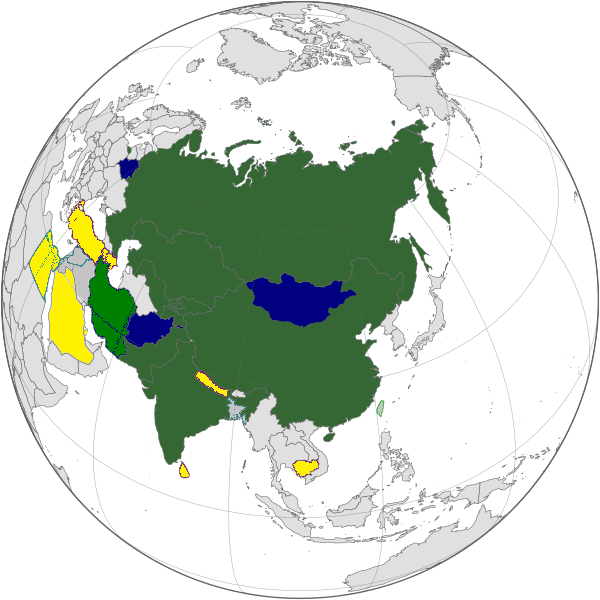
English: Map of the Shanghai Cooperation Organization.
Strict definition - Member states Broad definition: Chinese disputed territories, Observer states, Dialogue Partners Русский: Карта Шанхайской Организации Сотрудничества. Строгое определение - страны члены Широкое определение: Китайские спорные территории, страны наблюдатели, партнеры по диалогу |
||||||||
| 日脚 | 2005年4月12日, updated on 20 June 2009 | ||||||||
| 来源 | |||||||||
| 作者 | Aris Katsaris, updated by Emilfaro | ||||||||
| 许可协议 (重用本文件) |
|

文件历史
揿一个日脚/辰光来望当时出现过个文件。
| 日脚 / 辰光 | 微缩图 | 维度 | 用户 | 备注 | |
|---|---|---|---|---|---|
| 当前 | 2022年9月20号 (两) 15:22 | | 600 × 600(139 KB) | Yuri V. | correct version, without errors |
| 2017年9月18号 (一) 19:07 |  | 600 × 600(173 KB) | Hwatas | India and Pakistan | |
| 2009年6月20号 (六) 11:28 |  | 1,200 × 1,200(367 KB) | Emilfaro | Orthographic projection. | |
| 2009年6月16号 (两) 20:48 |  | 1,567 × 692(177 KB) | Honmingjun | Change the color of Taiwan | |
| 2009年2月8号 (日) 19:41 |  | 1,567 × 692(218 KB) | Emilfaro | Based on SVG. | |
| 2008年10月25号 (六) 14:25 |  | 1,425 × 625(34 KB) | KAVO | {{Information |Description= |Source= |Date= |Author= |Permission= |other_versions= }} | |
| 2008年10月22号 (三) 20:37 |  | 1,425 × 625(58 KB) | Emilfaro | Turkmenistan color changed. | |
| 2008年10月22号 (三) 20:35 |  | 1,425 × 625(31 KB) | Emilfaro | Sorry, Turkmenistan is still CIS, thus a Guest Attendance. | |
| 2008年10月19号 (日) 02:39 |  | 1,425 × 625(31 KB) | Emilfaro | Turkmenistan was included by mistake. | |
| 2008年10月19号 (日) 02:15 |  | 1,425 × 625(31 KB) | Emilfaro | Global map as the alliance is large. |
文件用法
呒一页用着箇文件。
全域文件用场
下底个其他wiki使用箇只文件:
- da.wikipedia.org上个用途
- en.wikipedia.org上个用途
- es.wikipedia.org上个用途
- fr.wikinews.org上个用途
- simple.wikipedia.org上个用途
- zh.wikipedia.org上个用途