File:CapeHornDetailMap.png
原始文件 (906×546像素,文件大小:91 KB,MIME类型:image/png)
小结
| 描述 |
Español: Detalle de las islas cerca del Cabo de Hornos
Generated using GMT. |
| 日脚 | 2006年1月27日 (原始上传日期) |
| 来源 | 自家个作品 |
| 作者 | Johantheghost |
授权协议
我,本作品著作权人,特此采用以下许可协议发表本作品:

|
已授权复制、传播搭/或修改本文档,依据自由软件基金会发布个GNU自由文档许可证1.2版或任何后续版本个条款;呒不弗可变章节,也呒不封面封底文字。许可证个副本包括勒GNU Free Documentation License章节当中。 |
| 本文件用知识共享“署名-相同方式共享 3.0 未本地化版本”许可协议授权。 | ||
| ||
| 本许可协议标签作为GFDL许可协议更新的组成部分被添加至本文件。 |
- 侬可以自由地:
- 分享 – 复制、发行、展览、表演、放映、广播或通过信息网络传播本作品
- 修改 – 改编本作品
- 来箇眼条件下底:
- 署名 – 侬板定要畀出适当个署名,提供许可协议个链接,同时标明侬阿有改动过。侬好用任何合理个方式来做,但必过弗好用任何方式暗示许可人是侬或侬个使用背书。
- 相同方式共享 – 如果你混合、转换或基于此素材创作,你板定要用搭原来相同或兼容个许可协议分发你个贡献作品。
侬好选择侬需要个许可协议。
文件历史
揿一个日脚/辰光来望当时出现过个文件。
| 日脚 / 辰光 | 微缩图 | 维度 | 用户 | 备注 | |
|---|---|---|---|---|---|
| 当前 | 2009年11月22号 (日) 00:17 | 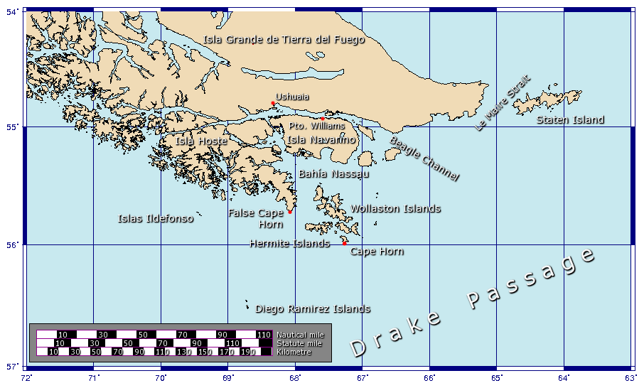 | 906 × 546(91 KB) | Botaurus | functionless line (borderline) removed |
| 2006年2月9号 (四) 20:22 |  | 906 × 546(91 KB) | Johantheghost | Less violent colours. | |
| 2006年1月28号 (六) 08:25 |  | 906 × 546(90 KB) | Johantheghost | Fix scale! | |
| 2006年1月28号 (六) 04:20 |  | 906 × 546(87 KB) | Johantheghost | Scale and false cape | |
| 2006年1月28号 (六) 00:34 |  | 906 × 546(81 KB) | Johantheghost | A map showing the location of Cape Horn, including part of the Drake Passage. Generated using [http://gmt.soest.hawaii.edu/ GMT]. |
文件用法
下向许1张用着箇文件:
全域文件用场
下底个其他wiki使用箇只文件:
- af.wikipedia.org上个用途
- als.wikipedia.org上个用途
- ar.wikipedia.org上个用途
- ast.wikipedia.org上个用途
- az.wikipedia.org上个用途
- be-tarask.wikipedia.org上个用途
- be.wikipedia.org上个用途
- bg.wikipedia.org上个用途
- br.wikipedia.org上个用途
- bs.wikipedia.org上个用途
- ca.wikipedia.org上个用途
- ceb.wikipedia.org上个用途
- ckb.wikipedia.org上个用途
- cy.wikipedia.org上个用途
- da.wikipedia.org上个用途
- de.wikipedia.org上个用途
- el.wikipedia.org上个用途
- en.wikipedia.org上个用途
- eo.wikipedia.org上个用途
- es.wikipedia.org上个用途
- et.wikipedia.org上个用途
- eu.wikipedia.org上个用途
- fa.wikipedia.org上个用途
- fi.wikipedia.org上个用途
- frr.wikipedia.org上个用途
- fr.wikipedia.org上个用途
查看本文件个更多全域用途。