File:Kingdoms of Israel and Judah map 830-es.svg

此SVG文件的PNG预览的大小:503×600像素。 其他分辨率:201×240像素 | 402×480像素 | 644×768像素 | 858×1,024像素 | 1,717×2,048像素 | 768×916像素。
原始文件 (SVG文件,名义大小:768×916像素,文件大小:393 KB)
| 描述 |
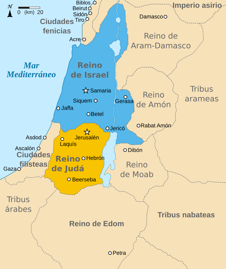
Español: Mapa mostrando los reinos de Israel (azul) y de Judá (naranja) showing the Kingdoms of Israel (blue) and Judah (orange), antiguas fronteras levantinas y ciudades como Damasco y Gerasa. El mapa muestra la región en torno al siglo IX a. C. |
| 日脚 | (UTC) |
| 来源 | |
| 作者 |
|
| 其他版本 |
[]
|


| 这是一张修改过的图片,这意味着它已在原版本的基础上通过软件进行了编辑,改动内容:translated to Spanish。其原始版本为:Kingdoms of Israel and Judah map 830.svg。修改者: Kordas。
|
我,本作品著作权人,特此采用以下许可协议发表本作品:
本文件用知识共享“署名-相同方式共享 3.0 未本地化版本”许可协议授权。
- 侬可以自由地:
- 分享 – 复制、发行、展览、表演、放映、广播或通过信息网络传播本作品
- 修改 – 改编本作品
- 来箇眼条件下底:
- 署名 – 侬板定要畀出适当个署名,提供许可协议个链接,同时标明侬阿有改动过。侬好用任何合理个方式来做,但必过弗好用任何方式暗示许可人是侬或侬个使用背书。
- 相同方式共享 – 如果你混合、转换或基于此素材创作,你板定要用搭原来相同或兼容个许可协议分发你个贡献作品。

|
已授权复制、传播搭/或修改本文档,依据自由软件基金会发布个GNU自由文档许可证1.2版或任何后续版本个条款;呒不弗可变章节,也呒不封面封底文字。许可证个副本包括勒GNU Free Documentation License章节当中。 |
侬好选择侬需要个许可协议。
原始上传日志
This image is a derivative work of the following images:
- File:Kingdoms_of_Israel_and_Judah_map_830.svg licensed with Cc-by-sa-3.0, GFDL
- 2010-07-13T11:29:47Z Richardprins 720x859 (80899 Bytes) Fixed Judah color
- 2010-07-13T10:51:49Z Richardprins 720x859 (80858 Bytes) Added colors for the two kingdoms and converted their text to path and arial
- 2010-07-12T23:53:35Z Richardprins 720x859 (63843 Bytes) Shrinked down the borders
- 2010-07-12T19:43:31Z Richardprins 720x859 (63800 Bytes) {{Information |Description={{en|1=Map showing the ancient levant borders and ancient cities such as [[Urmomium]] and [[Jerash]]. The map also shows the region in the 9th century BCE. Notice the coastal land of Philistia, from
Uploaded with derivativeFX
文件历史
揿一个日脚/辰光来望当时出现过个文件。
| 日脚 / 辰光 | 微缩图 | 维度 | 用户 | 备注 | |
|---|---|---|---|---|---|
| 当前 | 2017年3月20号 (一) 15:28 | | 768 × 916(393 KB) | Rowanwindwhistler | Fake text added |
| 2010年9月24号 (五) 02:22 |  | 720 × 859(65 KB) | Kordas | {{Information |Description={{es|1=Mapa mostrando los reinos de Israel (azul) y de Judá (naranja) showing the Kingdoms of Israel (blue) and Judah (orange), antiguas fronteras levantinas y ciudades como Damasco y Gerasa. El mapa muestra la región en torno |
文件用法
下向许1张用着箇文件:
全域文件用场
下底个其他wiki使用箇只文件:
- ast.wikipedia.org上个用途
- ca.wikipedia.org上个用途
- es.wikipedia.org上个用途
- eu.wikipedia.org上个用途
- gl.wikipedia.org上个用途