File:LakeKivu satellite.jpg
无更高分辨率可提供。
LakeKivu_satellite.jpg (296×464像素,文件大小:21 KB,MIME类型:image/jpeg)
小结
| 描述 |
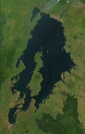
English: Lake Kivu, Africa, as seen from space. The black line marks the border between Rwanda and the Democratic Republic of the Congo. Cropped from a larger image (EAfrica.A2003033.0820.250m.jpg). |
| 日脚 | |
| 来源 | "Fires in East Africa" - Visible Earth Image ID 4957 (details, image at 250m resolution) |
| 作者 | NASA |
授权协议
| 本文件完全由NASA创作,在美国属于公有领域。根据NASA的版权方针,NASA的材料除非另有声明否则不受版权保护。(参见Template:PD-USGov/zh、NASA版权方针页面或JPL图片使用方针。) | ||
 |
警告:
|
原始上传日志
from en.wikipedia.org
- Uploaded on 23 February 2006 by en:User:Paphrag.
文件历史
揿一个日脚/辰光来望当时出现过个文件。
| 日脚 / 辰光 | 微缩图 | 维度 | 用户 | 备注 | |
|---|---|---|---|---|---|
| 当前 | 2010年9月19号 (日) 22:19 | | 296 × 464(21 KB) | LobStoR | lossless crop from source NASA image at 250m resolution |
| 2006年5月25号 (四) 06:43 |  | 295 × 476(108 KB) | Dubhe | from en.wiki |
文件用法
下向许1张用着箇文件:
全域文件用场
下底个其他wiki使用箇只文件:
- af.wikipedia.org上个用途
- ar.wikipedia.org上个用途
- arz.wikipedia.org上个用途
- ast.wikipedia.org上个用途
- bn.wikipedia.org上个用途
- br.wikipedia.org上个用途
- ca.wikipedia.org上个用途
- ceb.wikipedia.org上个用途
- cs.wikipedia.org上个用途
- da.wikipedia.org上个用途
- de.wikipedia.org上个用途
- de.wikivoyage.org上个用途
- dsb.wikipedia.org上个用途
- el.wikipedia.org上个用途
- en.wikipedia.org上个用途
- eo.wikipedia.org上个用途
- es.wikipedia.org上个用途
- et.wikipedia.org上个用途
- eu.wikipedia.org上个用途
- fa.wikipedia.org上个用途
- fi.wikipedia.org上个用途
- fr.wikipedia.org上个用途
- fr.wikivoyage.org上个用途
- gl.wikipedia.org上个用途
- he.wikipedia.org上个用途
- hsb.wikipedia.org上个用途
- hy.wikipedia.org上个用途
- ig.wikipedia.org上个用途
- it.wikipedia.org上个用途
- ja.wikipedia.org上个用途
- ka.wikipedia.org上个用途
- ko.wikipedia.org上个用途
查看本文件个更多全域用途。