File:Map-RB-1812-Westphalia.svg

原始文件 (SVG文件,名义大小:698×999像素,文件大小:796 KB)
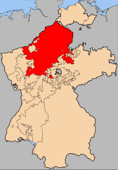
| 描述 | The Kingdom of Westphalia (de:Königreich Westphalen) within Germany at the time of the en:Confederation of the Rhine | |||||||||||
| 日脚 | ||||||||||||
| 来源 | en:Image:Map-RB-Frankfurt.svg by User:52 Pickup, not uploaded to commons. | |||||||||||
| 作者 | User:52 Pickup, User:Sir Iain | |||||||||||
| 许可协议 (重用本文件) |
本文件采用知识共享署名-相同方式共享 2.5 通用许可协议授权。
|

文件历史
揿一个日脚/辰光来望当时出现过个文件。
| 日脚 / 辰光 | 微缩图 | 维度 | 用户 | 备注 | |
|---|---|---|---|---|---|
| 当前 | 2008年4月21号 (一) 01:26 | | 698 × 999(796 KB) | Sir Iain | {{Information| |Description= The Kingdom of Westphalia (de:Königreich Westphalen) within Germany at the time of the en:Confederation of the Rhine |Source=en:Image:Map-RB-Frankfurt.svg by User:52 Pickup, no |
文件用法
下向许1张用着箇文件:
全域文件用场
下底个其他wiki使用箇只文件:
- azb.wikipedia.org上个用途
- be.wikipedia.org上个用途
- bg.wikipedia.org上个用途
- cs.wikipedia.org上个用途
- en.wikipedia.org上个用途
- et.wikipedia.org上个用途
- fr.wikipedia.org上个用途
- gd.wikipedia.org上个用途
- hu.wikipedia.org上个用途
- nl.wikipedia.org上个用途
- ru.wikipedia.org上个用途
- sv.wikipedia.org上个用途
- tr.wikipedia.org上个用途