File:PIA17202 - Approaching Enceladus.jpg
本预览个尺寸:600×600像素。 其他分辨率:240×240像素 | 480×480像素 | 1,020×1,020像素。
原始文件 (1,020×1,020像素,文件大小:1.1 MB,MIME类型:image/jpeg)
小结
| 描述 |
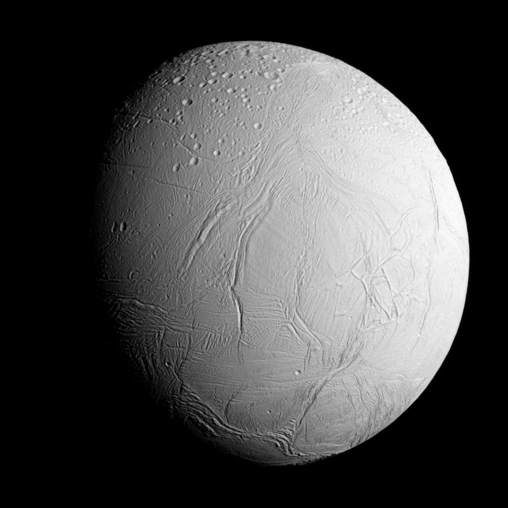
English: Original caption: NASA's Cassini spacecraft captured this view as it neared icy Enceladus for its closest-ever dive past the moon's active south polar region. The view shows heavily cratered northern latitudes at top, transitioning to fractured, wrinkled terrain in the middle and southern latitudes. The wavy boundary of the moon's active south polar region -- Cassini's destination for this flyby -- is visible at bottom, where it disappears into wintry darkness.
This view looks towards the Saturn-facing side of Enceladus. North on Enceladus is up and rotated 23 degrees to the right. The image was taken in visible light with the Cassini spacecraft narrow-angle camera on Oct. 28, 2015. The view was acquired at a distance of approximately 60,000 miles (96,000 kilometers) from Enceladus and at a Sun-Enceladus-spacecraft, or phase, angle of 45 degrees. Image scale is 1,896 feet (578 meters) per pixel. |
| 日脚 | |
| 来源 | PIA17202 from the NASA/JPL Photojournal |
| 作者 | National Aeronautics and Space Administration (NASA) / Jet Propulsion Laboratory (JPL) |
授权协议
| 本文件完全由NASA创作,在美国属于公有领域。根据NASA的版权方针,NASA的材料除非另有声明否则不受版权保护。(参见Template:PD-USGov/zh、NASA版权方针页面或JPL图片使用方针。) | ||
 |
警告:
|
文件历史
揿一个日脚/辰光来望当时出现过个文件。
| 日脚 / 辰光 | 微缩图 | 维度 | 用户 | 备注 | |
|---|---|---|---|---|---|
| 当前 | 2020年10月8号 (四) 15:20 | | 1,020 × 1,020(1.1 MB) | Vlixes | from tiff, rgb |
| 2015年10月31号 (六) 07:16 |  | 920 × 920(191 KB) | PhilipTerryGraham | User created page with UploadWizard |
文件用法
下向许1张用着箇文件:
全域文件用场
下底个其他wiki使用箇只文件:
- an.wikipedia.org上个用途
- ary.wikipedia.org上个用途
- arz.wikipedia.org上个用途
- azb.wikipedia.org上个用途
- bn.wikibooks.org上个用途
- bs.wikipedia.org上个用途
- ca.wikipedia.org上个用途
- ckb.wikipedia.org上个用途
- cs.wikipedia.org上个用途
- el.wikipedia.org上个用途
- en.wikipedia.org上个用途
- Pioneer 11
- Cassini–Huygens
- Enceladus
- Moons of Saturn
- Naming of moons
- List of natural satellites
- Dunyazad (crater)
- Ahmad (crater)
- Peri-Banu (crater)
- Aladdin (crater)
- Ali Baba (crater)
- Julnar (crater)
- Salih (crater)
- Dalilah (crater)
- Samad (crater)
- Musa (crater)
- Gharib (crater)
- Duban (crater)
- Shahryar (crater)
- Sindbad (crater)
- Daryabar Fossa
- Bassorah Fossa
- List of gravitationally rounded objects of the Solar System
- Al-Fakik
- Marjanah (crater)
- Ayyub (crater)
- Fitnah (crater)
- Ghanim (crater)
- Al-Haddar
- Sharrkan (crater)
- Khusrau (crater)
查看本文件个更多全域用途。