File:SE2015Mar20T.png
原始文件 (728×729像素,文件大小:27 KB,MIME类型:image/png)
小结
| 描述 |
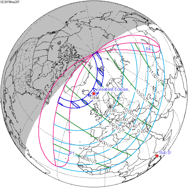
English: Solar eclipse A map of path on earth: Totality exists within the dark blue areas, partiality at the light blue areas. The eclipse occurs at sunrise or sunset in the pink areas. Light blue lines represent a constant fixed fraction of coverage. Green lines show lines of time for greatest coverage. For more information see [1] |
| 日脚 | |
| 来源 | http://eclipse.gsfc.nasa.gov/ |
| 作者 | Eclipse Predictions by Fred Espenak, NASA's GSFC |
![[1]](http://eclipse.gsfc.nasa.gov/SEplot/SEplot2001/SE2015Mar20T.GIF)
授权协议
| 本文件完全由NASA创作,在美国属于公有领域。根据NASA的版权方针,NASA的材料除非另有声明否则不受版权保护。(参见Template:PD-USGov/zh、NASA版权方针页面或JPL图片使用方针。) | ||
 |
警告:
|
原始上传日志
原始描述頁面位於這裡。下列使用者名稱均來自en.wikipedia。
- 2009-12-08 20:37 SockPuppetForTomruen 728×729× (91056 bytes)
- 2009-11-22 07:43 Tomruen 733×729× (91478 bytes) {{Information |Description = [[Solar eclipse]] map of path on earth |Source = http://eclipse.gsfc.nasa.gov/ |Date = 2000 |Author = Fred |Permission = Official work for NASA |other_versions = }} {{Attribution}} Attribution: '''Eclipse Pr
文件历史
揿一个日脚/辰光来望当时出现过个文件。
| 日脚 / 辰光 | 微缩图 | 维度 | 用户 | 备注 | |
|---|---|---|---|---|---|
| 当前 | 2015年7月17号 (五) 02:22 |  | 728 × 729(27 KB) | Cmdrjameson | Compressed with pngout. Reduced by 62kB (70% decrease). |
| 2011年8月9号 (两) 16:40 |  | 728 × 729(89 KB) | OgreBot | (BOT): Reverting to most recent version; originally uploaded at en.wikipedia on 2009-12-08 20:37:41 by SockPuppetForTomruen | |
| 2011年8月9号 (两) 16:40 |  | 733 × 729(89 KB) | OgreBot | (BOT): Uploading old version of file from en.wikipedia; originally uploaded on 2009-11-22 07:43:35 by Tomruen | |
| 2011年3月13号 (日) 18:13 |  | 728 × 729(89 KB) | SamZane | {{Information |Description ={{en|1=Solar eclipse of march 20 2015 map.}} |Source =NASA |Author =NASA |Date = |Permission = |other_versions = }} Category:Solar eclipse map |
文件用法
下向许1张用着箇文件:
全域文件用场
下底个其他wiki使用箇只文件:
- ar.wikipedia.org上个用途
- كسوف الشمس 20 مارس 2015
- كسوف الشمس 1 يونيو 2011
- كسوف الشمس 1 سبتمبر 2016
- كسوف الشمس 26 فبراير 2017
- كسوف الشمس 25 أكتوبر 2022
- كسوف الشمس 12 أغسطس 2026
- كسوف الشمس 30 مارس 2033
- كسوف الشمس 5 يناير 2038
- كسوف الشمس 25 أكتوبر 2041
- كسوف الشمس 12 أغسطس 2045
- كسوف الشمس 31 مايو 2049
- كسوف الشمس 11 أبريل 2051
- كسوف الشمس 20 مارس 2034
- كسوف الشمس 20 مارس 2053
- كسوف الشمس 12 أغسطس 2064
- كسوف الشمس 5 يناير 2057
- كسوف الشمس 24 أكتوبر 2060
- كسوف الشمس 31 مايو 2068
- كسوف الشمس 21 أبريل 2069
- كسوف الشمس 6 يناير 2019
- كسوف الشمس 2 مايو 2087
- كسوف الشمس 1 يونيو 2087
- كسوف الشمس 19 مارس 2072
- كسوف الشمس 7 فبراير 2073
- كسوف الشمس 3 أغسطس 2073
- كسوف الشمس 27 يناير 2074
- كسوف الشمس 6 يناير 2076
- كسوف الشمس 24 أكتوبر 2079
- كسوف الشمس 21 مارس 2080
- كسوف الشمس 13 سبتمبر 2080
- كسوف الشمس 10 مارس 2081
- كسوف الشمس 13 أغسطس 2083
- كسوف الشمس 7 يناير 2084
- كسوف الشمس 3 يوليو 2084
- كسوف الشمس 27 ديسمبر 2084
- كسوف الشمس 22 يونيو 2085
- كسوف الشمس 16 ديسمبر 2085
- az.wikipedia.org上个用途
- be.wikipedia.org上个用途
- bg.wikipedia.org上个用途
- bn.wikipedia.org上个用途
- el.wikipedia.org上个用途
- en.wikipedia.org上个用途
查看本文件个更多全域用途。