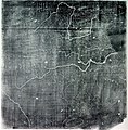
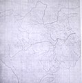
File:Song Dynasty Map.JPG

原始文件(756×768像素,文件大小:436 KB,MIME类型:image/jpeg

箇文件维基共享资源里个,作兴会畀别个项目使用。渠个描述页里个说明显示如下。

Info

描述

The Chinese Yu Ji Tu (Map of the Tracks of Yu the Great), a map carved into stone in the year 1137 during the Song Dynasty, located in the Stele Forest of modern-day Xian, China. Yu the Great refers to the Chinese deity described in the Chinese geographical work of the Yu Gong, a chapter of the Classic of History. Needham and Chavannes assert that the original map must have predated the 12th century.

The graduated scale of this gridded map is at 100 li (Chinese mile) squared for every representative square in the grid. The overall size of the map is 3 ft squared. The coastal outline is relatively firm and the precision of the network of river systems is incredibly accurate. The name of the geographers and cartographers who initially created the map are unknown. In the year 1142 a copy of the map was preserved at Zhenjiang in Jiangsu province by a certain Yu Chi, who was then a Prefectural Director of Studies. There is also mention of an earlier copy of about 1100 AD which itself was based on the Chang'an version. Needham asserts that the map was used primarily to instruct students while referring to sites described in the ancient Yu Gong chapter of the Classic of History.
日脚 printing of a rubbing of a c. 1136 engraving of a c. 1100 map
来源 Joseph Needham's Science and Technology in China, Vol. 3: Mathematics and the Sciences of the Heavens and the Earth, Plate LXXXI and text description pp. 547–549, hardback edition
作者 Unknown, photo by PericlesofAthens


Public domain

本作品在其来源国以及其他著作权期限是作者逝世后70年或以下的国家和地区属于公有领域


你必须增加美国公有领域标签显示为何这个作品在美国属于公有领域。 请注意少数国家的版权保护期为70年以上:墨西哥为100年,牙买加为95年,哥伦比亚为80年,危地马拉与萨摩亚为75年,而这些国家不实施较短期限法则,因此该图片可能在这些国家被认为是公有领域。洪都拉斯的版权期限一般为75年,但该国实施较短期限法则。对于在第二次世界大战期间为法国利益战死的法国人(更多信息)、二战期间参与过苏德战争(俄罗斯称之为伟大的卫国战争)的俄罗斯人,以及苏联时期遭到镇压,而死后获得平反的牺牲者(更多信息),这些人的作品版权期限会有所延长。

Public domain 我,本作品著作权人,释出本作品至公有领域。这适用于全世界。
在一些国家这可能不合法;如果是这样的话,那么:
我无条件地授予任何人以任何目的使用本作品的权利,除非这些条件是法律规定所必需的。

说明

添加一行文字以描述该文件所表现的内容

此文件中描述的项目

描绘内容 简体中文

成立或创建时间 简体中文

3 11 2007

文件历史

揿一个日脚/辰光来望当时出现过个文件。

日脚 / 辰光微缩图维度用户备注
当前2011年8月3号 (三) 15:25于2011年8月3号 (三) 15:25个缩图版本756 × 768(436 KB)Dragonet~commonswikibetter quality
2007年11月3号 (六) 18:32于2007年11月3号 (六) 18:32个缩图版本834 × 843(89 KB)PericlesofAthens{{Information |Description=The Chinese ''Yu Ji Tu'' (Map of the Tracks of Yu the Great), a map carved into stone in the year 1137 during the Song Dynasty, located in the Stele Forest of modern-day Xian, China. Yu the Great refers to the Chinese deity desc

呒一页用着箇文件。

全域文件用场

下底个其他wiki使用箇只文件:

元数据