File:Swat NWFP.svg

此SVG文件的PNG预览的大小:558×600像素。 其他分辨率:223×240像素 | 446×480像素 | 714×768像素 | 953×1,024像素 | 1,905×2,048像素 | 1,000×1,075像素。
原始文件 (SVG文件,名义大小:1,000×1,075像素,文件大小:202 KB)
小结
| 描述 |
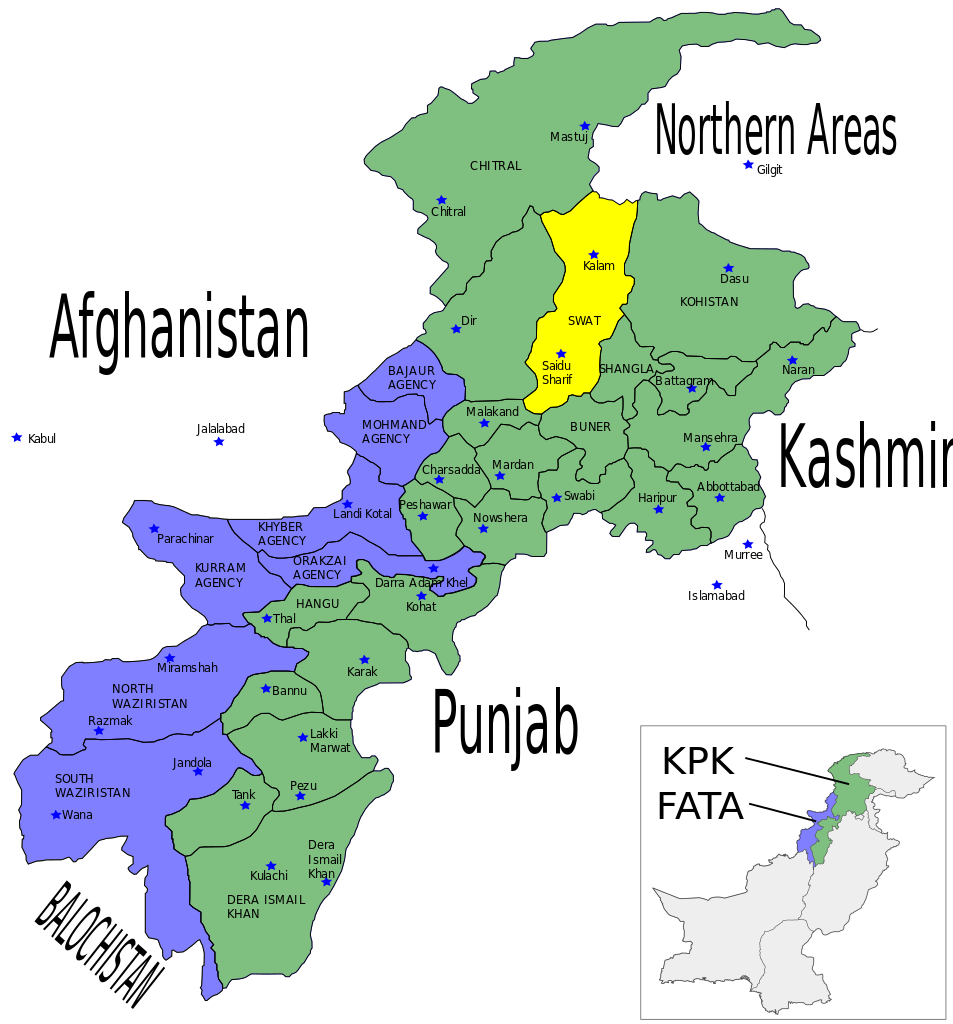
English: Map showing the location of Swat District (highlighted in yellow) within the Khyber-Pakhtunkhwa Province of Pakistan. |
| 日脚 | |
| 来源 | Self made using Inkscape - Based on maps from http://www.nwfp.gov.pk |
| 作者 | Pahari Sahib |
| 其他版本 | Derivative works of this file: NWPF-Pakistan.png |
授权协议
I, Pahari Sahib,本作品著作权人,特此采用以下许可协议发表本作品:

|
已授权复制、传播搭/或修改本文档,依据自由软件基金会发布个GNU自由文档许可证1.2版或任何后续版本个条款;呒不弗可变章节,也呒不封面封底文字。许可证个副本包括勒GNU Free Documentation License章节当中。 |
| 本文件用知识共享“署名-相同方式共享 3.0 未本地化版本”许可协议授权。 | ||
| 署名: I, Pahari Sahib | ||
| ||
| 本许可协议标签作为GFDL许可协议更新的组成部分被添加至本文件。 |
署名: I, Pahari Sahib
- 侬可以自由地:
- 分享 – 复制、发行、展览、表演、放映、广播或通过信息网络传播本作品
- 修改 – 改编本作品
- 来箇眼条件下底:
- 署名 – 侬板定要畀出适当个署名,提供许可协议个链接,同时标明侬阿有改动过。侬好用任何合理个方式来做,但必过弗好用任何方式暗示许可人是侬或侬个使用背书。
- 相同方式共享 – 如果你混合、转换或基于此素材创作,你板定要用搭原来相同或兼容个许可协议分发你个贡献作品。
侬好选择侬需要个许可协议。
文件历史
揿一个日脚/辰光来望当时出现过个文件。
| 日脚 / 辰光 | 微缩图 | 维度 | 用户 | 备注 | |
|---|---|---|---|---|---|
| 当前 | 2010年5月17号 (一) 07:54 | | 1,000 × 1,075(202 KB) | Guillaume70 | New version : map showing Pakistan + NWPF => PKP Category:SVG maps of Pakistan |
| 2007年6月12号 (两) 12:03 |  | 1,000 × 1,075(171 KB) | Pahari Sahib | {{Information |Description=Map showing the location of Swat District (highlighted in yellow) within the North-West Frontier Province (NWFP) of Pakistan. |Source=Self made using Inkscape - Based on maps from http://www.nwfp.gov.pk |Date=12/06/07 |A |
文件用法
呒一页用着箇文件。
全域文件用场
下底个其他wiki使用箇只文件:
- da.wikipedia.org上个用途
- fr.wikipedia.org上个用途
- nl.wikipedia.org上个用途
- no.wikipedia.org上个用途
- pnb.wikipedia.org上个用途
- www.wikidata.org上个用途