File:Tianjin 20051107 concessions coloured.jpg

本预览个尺寸:599×600像素。 其他分辨率:240×240像素 | 479×480像素 | 767×768像素 | 1,023×1,024像素 | 1,448×1,450像素。
原始文件 (1,448×1,450像素,文件大小:1.65 MB,MIME类型:image/jpeg)
| 描述 |
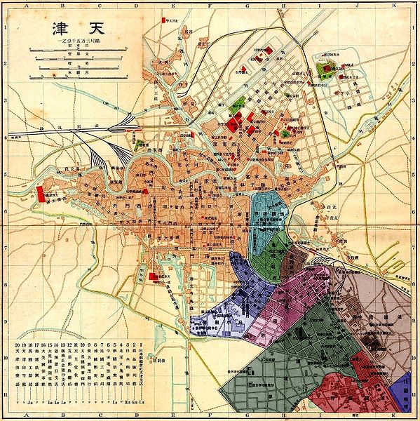
Colours/顏色/颜色: Eastern bank of the Hai River (previously called Pei Ho)/海河東浦/海河东浦: Austria-Hungary/奧匈帝國/奥匈帝国
俄罗斯 (2 separated areas/兩部分/两部分)
Western bank of the Hai River/海河西浦: |
| 日脚 | (UTC) |
| 来源 | |
| 作者 |
|
| 其他版本 |
 - another map of the same concessions/其他天津外國租界地圖/其他天津外国租界地图 - another map of the same concessions/其他天津外國租界地圖/其他天津外国租界地图 |
Notes
- ↑ Another separated part of the Japanese concession, south of the German one, is not visible on this map/本地圖沒說明日本租界的一小部分(地處德國租界南方)/本地图没说明日本租界的一小部分(地处德国租界南方).
|
|
原始上传日志
This image is a derivative work of the following images:
- Image:Tianjin_20051107.jpg licensed with PD-Art, PD-old
- 2005-11-07T11:51:18Z Yaohua2000 1448x1450 (636923 Bytes) Map of [[w:Tianjin|Tianjin]] around 1930s.
Uploaded with derivativeFX
文件历史
揿一个日脚/辰光来望当时出现过个文件。
| 日脚 / 辰光 | 微缩图 | 维度 | 用户 | 备注 | |
|---|---|---|---|---|---|
| 当前 | 2008年9月8号 (一) 06:50 | | 1,448 × 1,450(1.65 MB) | Gugganij | minor edit |
| 2008年9月8号 (一) 05:45 |  | 1,448 × 1,450(1.65 MB) | Gugganij | {{Information |Description=*{{en|Map of Tianjin with concessions in colour.}} *{{de|Karte von Tianjin. Die Konzessionsgebiete wurden eingefärbt.}} |Source=*Image:Tianjin_20051107.jpg |Date=2008-09-07 21:42 (UTC) |Author=*derivative work: ~~ |
文件用法
下向许1张用着箇文件:
全域文件用场
下底个其他wiki使用箇只文件:
- ar.wikipedia.org上个用途
- ca.wikipedia.org上个用途
- cs.wikipedia.org上个用途
- de.wikipedia.org上个用途
- en.wikipedia.org上个用途
- es.wikipedia.org上个用途
- fr.wikipedia.org上个用途
- he.wikipedia.org上个用途
- hu.wikipedia.org上个用途
- hy.wikipedia.org上个用途
- is.wikipedia.org上个用途
- it.wikipedia.org上个用途
- pt.wikipedia.org上个用途
- ru.wikipedia.org上个用途
- uk.wikipedia.org上个用途
- vi.wikipedia.org上个用途
- zh.wikipedia.org上个用途